Using the Snapshotter
This guide will help you walk through how to use MapSnapshotter.
Map Snapshot with Local Style
Note
You can find the full source code of this example in MapSnapshotterLocalStyleActivity.kt of the MapLibreAndroidTestApp.
To get started we will show how to use the map snapshotter with a local style.
Add the source code of the Demotiles style as demotiles.json to the res/raw directory of our app1. First we will read this style:
Next, we configure the MapSnapshotter, passing height and width, the style we just read and the camera position:
mapSnapshotter = MapSnapshotter(
    applicationContext,
    MapSnapshotter.Options(
        container.measuredWidth.coerceAtMost(1024),
        container.measuredHeight.coerceAtMost(1024)
    )
        .withStyleBuilder(Style.Builder().fromJson(styleJson))
        .withCameraPosition(
            CameraPosition.Builder().target(LatLng(LATITUDE, LONGITUDE))
                .zoom(ZOOM).build()
        )
)
Lastly we use the .start() method to create the snapshot, and pass callbacks for when the snapshot is ready or for when an error occurs.
mapSnapshotter.start({ snapshot ->
    Timber.i("Snapshot ready")
    val imageView = findViewById<View>(R.id.snapshot_image) as ImageView
    imageView.setImageBitmap(snapshot.bitmap)
}) { error -> Timber.e(error )}
Show a Grid of Snapshots
Note
You can find the full source code of this example in MapSnapshotterActivity.kt of the MapLibreAndroidTestApp.
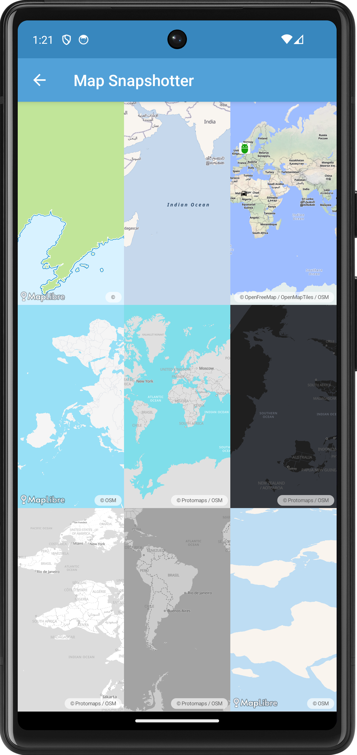
In this example, we demonstrate how to use the MapSnapshotter to create multiple map snapshots with different styles and camera positions, displaying them in a grid layout.

First we create a GridLayout and a list of MapSnapshotter instances. We create a Style.Builder with a different style for each cell in the grid.
val styles = arrayOf(
    TestStyles.DEMOTILES,
    TestStyles.AMERICANA,
    TestStyles.OPENFREEMAP_LIBERTY,
    TestStyles.AWS_OPEN_DATA_STANDARD_LIGHT,
    TestStyles.PROTOMAPS_LIGHT,
    TestStyles.PROTOMAPS_DARK,
    TestStyles.PROTOMAPS_WHITE,
    TestStyles.PROTOMAPS_GRAYSCALE
)
val builder = Style.Builder().fromUri(
    styles[(row * grid.rowCount + column) % styles.size]
)
Next we create a MapSnapshotter.Options object to customize the settings of each snapshot(ter).
val options = MapSnapshotter.Options(
    grid.measuredWidth / grid.columnCount,
    grid.measuredHeight / grid.rowCount
)
    .withPixelRatio(1f)
    .withLocalIdeographFontFamily(MapLibreConstants.DEFAULT_FONT)
For some rows we randomize the visible region of the snapshot:
if (row % 2 == 0) {
    options.withRegion(
        LatLngBounds.Builder()
            .include(
                LatLng(
                    randomInRange(-80f, 80f).toDouble(),
                    randomInRange(-160f, 160f).toDouble()
                )
            )
            .include(
                LatLng(
                    randomInRange(-80f, 80f).toDouble(),
                    randomInRange(-160f, 160f).toDouble()
                )
            )
            .build()
    )
}
For some columns we randomize the camera position:
if (column % 2 == 0) {
    options.withCameraPosition(
        CameraPosition.Builder()
            .target(
                options.region?.center ?: LatLng(
                    randomInRange(-80f, 80f).toDouble(),
                    randomInRange(-160f, 160f).toDouble()
                )
            )
            .bearing(randomInRange(0f, 360f).toDouble())
            .tilt(randomInRange(0f, 60f).toDouble())
            .zoom(randomInRange(0f, 10f).toDouble())
            .padding(1.0, 1.0, 1.0, 1.0)
            .build()
    )
}
In the last column of the first row we add two bitmaps. See the next example for more details.
if (row == 0 && column == 2) {
    val carBitmap = BitmapUtils.getBitmapFromDrawable(
        ResourcesCompat.getDrawable(resources, R.drawable.ic_directions_car_black, theme)
    )

    // Marker source
    val markerCollection = FeatureCollection.fromFeatures(
        arrayOf(
            Feature.fromGeometry(
                Point.fromLngLat(4.91638, 52.35673),
                featureProperties("1", "Android")
            ),
            Feature.fromGeometry(
                Point.fromLngLat(4.91638, 12.34673),
                featureProperties("2", "Car")
            )
        )
    )
    val markerSource: Source = GeoJsonSource(MARKER_SOURCE, markerCollection)

    // Marker layer
    val markerSymbolLayer = SymbolLayer(MARKER_LAYER, MARKER_SOURCE)
        .withProperties(
            PropertyFactory.iconImage(Expression.get(TITLE_FEATURE_PROPERTY)),
            PropertyFactory.iconIgnorePlacement(true),
            PropertyFactory.iconAllowOverlap(true),
            PropertyFactory.iconSize(
                Expression.switchCase(
                    Expression.toBool(Expression.get(SELECTED_FEATURE_PROPERTY)),
                    Expression.literal(1.5f),
                    Expression.literal(1.0f)
                )
            ),
            PropertyFactory.iconAnchor(Property.ICON_ANCHOR_BOTTOM),
            PropertyFactory.iconColor(Color.BLUE)
        )
    builder.withImage("Car", Objects.requireNonNull(carBitmap!!), false)
        .withSources(markerSource)
        .withLayers(markerSymbolLayer)
    options
        .withRegion(null)
        .withCameraPosition(
            CameraPosition.Builder()
                .target(
                    LatLng(5.537109374999999, 52.07950600379697)
                )
                .zoom(1.0)
                .padding(1.0, 1.0, 1.0, 1.0)
                .build()
        )
}
Map Snapshot with Bitmap Overlay
Note
You can find the full source code of this example in MapSnapshotterBitMapOverlayActivity.kt of the MapLibreAndroidTestApp.
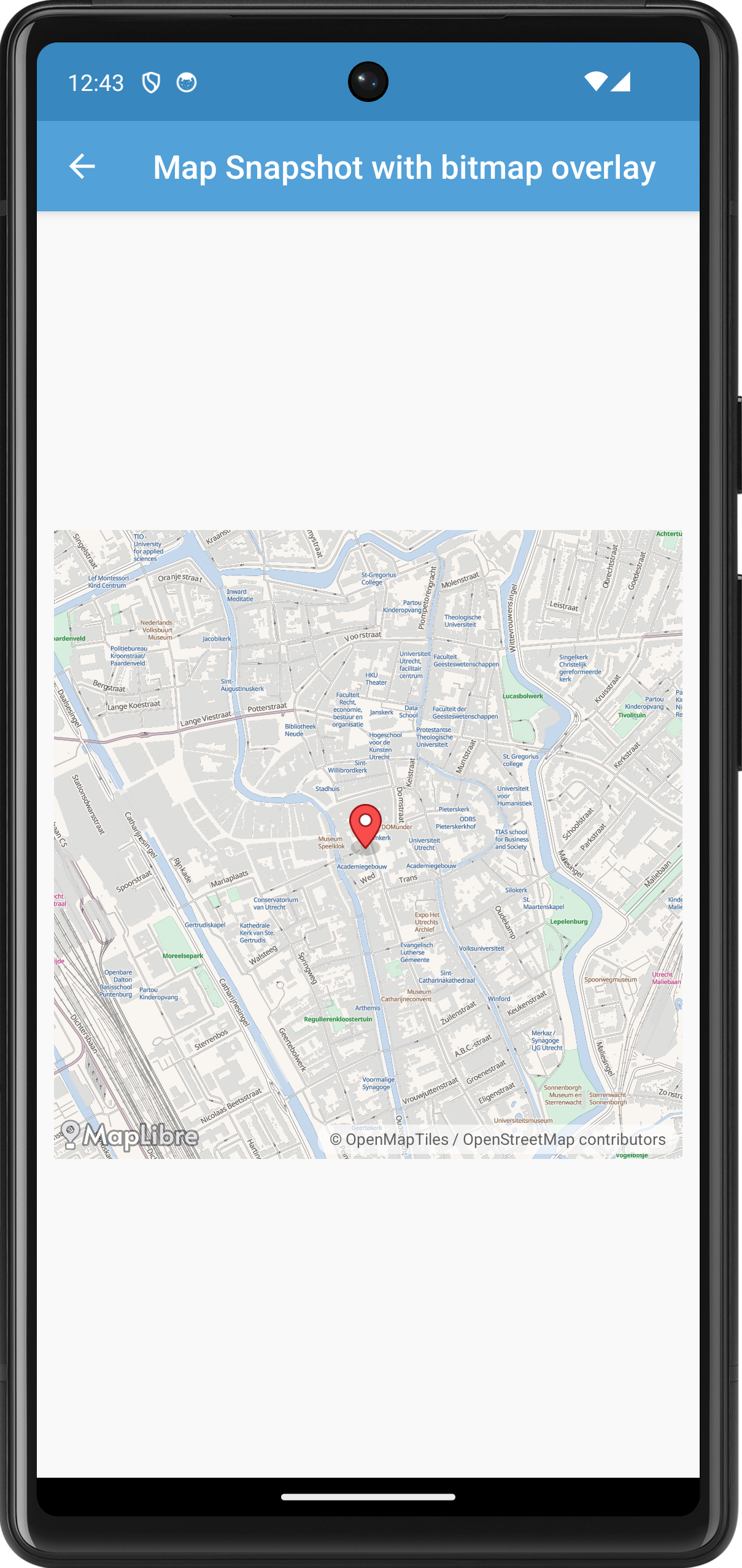
This example adds a bitmap on top of the snapshot. It also demonstrates how you can add a click listener to a snapshot.

package org.maplibre.android.testapp.activity.snapshot

import android.annotation.SuppressLint
import android.graphics.Bitmap
import android.graphics.BitmapFactory
import android.graphics.Canvas
import android.graphics.PointF
import android.os.Bundle
import android.view.MotionEvent
import android.view.View
import android.view.ViewTreeObserver.OnGlobalLayoutListener
import android.widget.ImageView
import androidx.annotation.VisibleForTesting
import androidx.appcompat.app.AppCompatActivity
import org.maplibre.android.camera.CameraPosition
import org.maplibre.android.geometry.LatLng
import org.maplibre.android.maps.Style
import org.maplibre.android.snapshotter.MapSnapshot
import org.maplibre.android.snapshotter.MapSnapshotter
import org.maplibre.android.testapp.R
import org.maplibre.android.testapp.styles.TestStyles
import timber.log.Timber

/**
 * Test activity showing how to use a the [MapSnapshotter] and overlay
 * [android.graphics.Bitmap]s on top.
 */
class MapSnapshotterBitMapOverlayActivity :
    AppCompatActivity(),
    MapSnapshotter.SnapshotReadyCallback {
    private var mapSnapshotter: MapSnapshotter? = null

    @get:VisibleForTesting
    var mapSnapshot: MapSnapshot? = null
        private set

    override fun onCreate(savedInstanceState: Bundle?) {
        super.onCreate(savedInstanceState)
        setContentView(R.layout.activity_map_snapshotter_marker)
        val container = findViewById<View>(R.id.container)
        container.viewTreeObserver
            .addOnGlobalLayoutListener(object : OnGlobalLayoutListener {
                override fun onGlobalLayout() {
                    container.viewTreeObserver.removeOnGlobalLayoutListener(this)
                    Timber.i("Starting snapshot")
                    mapSnapshotter = MapSnapshotter(
                        applicationContext,
                        MapSnapshotter.Options(
                            Math.min(container.measuredWidth, 1024),
                            Math.min(container.measuredHeight, 1024)
                        )
                            .withStyleBuilder(
                                Style.Builder().fromUri(TestStyles.AMERICANA)
                            )
                            .withCameraPosition(
                                CameraPosition.Builder().target(LatLng(52.090737, 5.121420))
                                    .zoom(15.0).build()
                            )
                    )
                    mapSnapshotter!!.start(this@MapSnapshotterBitMapOverlayActivity)
                }
            })
    }

    override fun onStop() {
        super.onStop()
        mapSnapshotter!!.cancel()
    }

    @SuppressLint("ClickableViewAccessibility")
    override fun onSnapshotReady(snapshot: MapSnapshot) {
        mapSnapshot = snapshot
        Timber.i("Snapshot ready")
        val imageView = findViewById<View>(R.id.snapshot_image) as ImageView
        val image = addMarker(snapshot)
        imageView.setImageBitmap(image)
        imageView.setOnTouchListener { v: View?, event: MotionEvent ->
            if (event.action == MotionEvent.ACTION_DOWN) {
                val latLng = snapshot.latLngForPixel(PointF(event.x, event.y))
                Timber.e("Clicked LatLng is %s", latLng)
                return@setOnTouchListener true
            }
            false
        }
    }

    private fun addMarker(snapshot: MapSnapshot): Bitmap {
        val canvas = Canvas(snapshot.bitmap)
        val marker =
            BitmapFactory.decodeResource(resources, R.drawable.maplibre_marker_icon_default, null)
        // Dom toren
        val markerLocation = snapshot.pixelForLatLng(LatLng(52.090649433011315, 5.121310651302338))
        canvas.drawBitmap(
            marker, /* Subtract half of the width so we center the bitmap correctly */
            markerLocation.x - marker.width / 2, /* Subtract half of the height so we align the bitmap bottom correctly */
            markerLocation.y - marker.height / 2,
            null
        )
        return snapshot.bitmap
    }
}
Map Snapshotter with Heatmap Layer
Note
You can find the full source code of this example in MapSnapshotterHeatMapActivity.kt of the MapLibreAndroidTestApp.
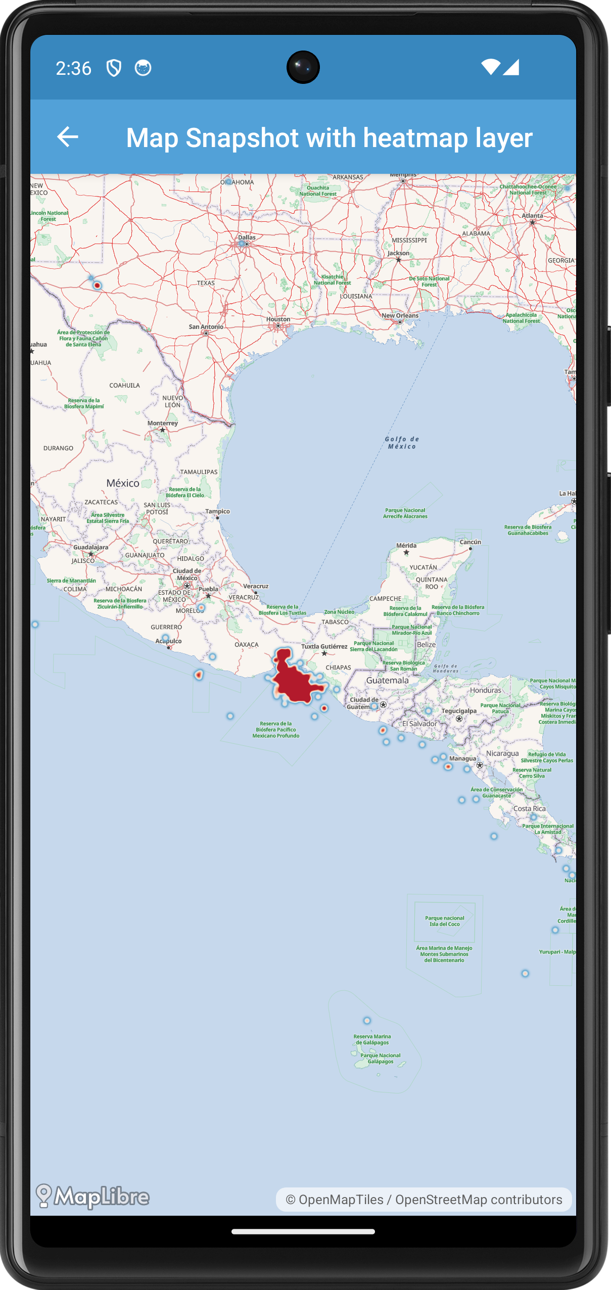
In this example, we demonstrate how to use the MapSnapshotter to create a snapshot of a map that includes a heatmap layer. The heatmap represents earthquake data loaded from a GeoJSON source.

First, we create the MapSnapshotterHeatMapActivity class, which extends AppCompatActivity and implements MapSnapshotter.SnapshotReadyCallback to receive the snapshot once it's ready.
In the onCreate method, we set up the layout and initialize the MapSnapshotter once the layout is ready.
override fun onCreate(savedInstanceState: Bundle?) {
    super.onCreate(savedInstanceState)
    setContentView(R.layout.activity_map_snapshotter_marker)
    val container = findViewById<View>(R.id.container)
    container.viewTreeObserver
        .addOnGlobalLayoutListener(object : OnGlobalLayoutListener {
            override fun onGlobalLayout() {
                container.viewTreeObserver.removeOnGlobalLayoutListener(this)
                Timber.i("Starting snapshot")
                val builder = Style.Builder().fromUri(TestStyles.AMERICANA)
                    .withSource(earthquakeSource!!)
                    .withLayerAbove(heatmapLayer, "water")
                mapSnapshotter = MapSnapshotter(
                    applicationContext,
                    MapSnapshotter.Options(container.measuredWidth, container.measuredHeight)
                        .withStyleBuilder(builder)
                        .withCameraPosition(
                            CameraPosition.Builder()
                                .target(LatLng(15.0, (-94).toDouble()))
                                .zoom(5.0)
                                .padding(1.0, 1.0, 1.0, 1.0)
                                .build()
                        )
                )
                mapSnapshotter!!.start(this@MapSnapshotterHeatMapActivity)
            }
        })
}
Here, we wait for the layout to be laid out using an OnGlobalLayoutListener before initializing the MapSnapshotter. We create a Style.Builder with a base style (TestStyles.AMERICANA), add the earthquake data source, and add the heatmap layer above the "water" layer.
The heatmapLayer property defines the HeatmapLayer used to visualize the earthquake data.
private val heatmapLayer: HeatmapLayer
    get() {
        val layer = HeatmapLayer(HEATMAP_LAYER_ID, EARTHQUAKE_SOURCE_ID)
        layer.maxZoom = 9f
        layer.sourceLayer = HEATMAP_LAYER_SOURCE
        layer.setProperties(
            PropertyFactory.heatmapColor(
                Expression.interpolate(
                    Expression.linear(), Expression.heatmapDensity(),
                    Expression.literal(0), Expression.rgba(33, 102, 172, 0),
                    Expression.literal(0.2), Expression.rgb(103, 169, 207),
                    Expression.literal(0.4), Expression.rgb(209, 229, 240),
                    Expression.literal(0.6), Expression.rgb(253, 219, 199),
                    Expression.literal(0.8), Expression.rgb(239, 138, 98),
                    Expression.literal(1), Expression.rgb(178, 24, 43)
                )
            ),
            PropertyFactory.heatmapWeight(
                Expression.interpolate(
                    Expression.linear(),
                    Expression.get("mag"),
                    Expression.stop(0, 0),
                    Expression.stop(6, 1)
                )
            ),
            PropertyFactory.heatmapIntensity(
                Expression.interpolate(
                    Expression.linear(),
                    Expression.zoom(),
                    Expression.stop(0, 1),
                    Expression.stop(9, 3)
                )
            ),
            PropertyFactory.heatmapRadius(
                Expression.interpolate(
                    Expression.linear(),
                    Expression.zoom(),
                    Expression.stop(0, 2),
                    Expression.stop(9, 20)
                )
            ),
            PropertyFactory.heatmapOpacity(
                Expression.interpolate(
                    Expression.linear(),
                    Expression.zoom(),
                    Expression.stop(7, 1),
                    Expression.stop(9, 0)
                )
            )
        )
        return layer
    }
This code sets up the heatmap layer's properties, such as color ramp, weight, intensity, radius, and opacity, using expressions that interpolate based on data properties and zoom level.
We also define the earthquakeSource, which loads data from a GeoJSON file containing earthquake information.
private val earthquakeSource: Source?
    get() {
        var source: Source? = null
        try {
            source = GeoJsonSource(EARTHQUAKE_SOURCE_ID, URI(EARTHQUAKE_SOURCE_URL))
        } catch (uriSyntaxException: URISyntaxException) {
            Timber.e(uriSyntaxException, "That's not a valid URL.")
        }
        return source
    }
When the snapshot is ready, the onSnapshotReady callback is invoked, where we set the snapshot bitmap to an ImageView to display it.
@SuppressLint("ClickableViewAccessibility")
override fun onSnapshotReady(snapshot: MapSnapshot) {
    Timber.i("Snapshot ready")
    val imageView = findViewById<ImageView>(R.id.snapshot_image)
    imageView.setImageBitmap(snapshot.bitmap)
}
Finally, we ensure to cancel the snapshotter in the onStop method to free up resources.
Map Snapshotter with Expression
Note
You can find the full source code of this example in MapSnapshotterWithinExpression.kt of the MapLibreAndroidTestApp.
In this example the map on top is a live while the map on the bottom is a snapshot that is updated as you pan the map. We style of the snapshot is modified: using a within expression only POIs within a certain distance to a line is shown. A highlight for this area is added to the map as are various points.
package org.maplibre.android.testapp.activity.turf

import android.graphics.Color
import android.os.Bundle
import android.os.PersistableBundle
import androidx.appcompat.app.AppCompatActivity
import org.maplibre.geojson.*
import org.maplibre.android.camera.CameraPosition
import org.maplibre.android.camera.CameraUpdateFactory
import org.maplibre.android.geometry.LatLng
import org.maplibre.android.maps.MapView
import org.maplibre.android.maps.MapLibreMap
import org.maplibre.android.maps.Style
import org.maplibre.android.snapshotter.MapSnapshot
import org.maplibre.android.snapshotter.MapSnapshotter
import org.maplibre.android.style.expressions.Expression.within
import org.maplibre.android.style.layers.CircleLayer
import org.maplibre.android.style.layers.FillLayer
import org.maplibre.android.style.layers.LineLayer
import org.maplibre.android.style.layers.Property.NONE
import org.maplibre.android.style.layers.PropertyFactory.*
import org.maplibre.android.style.layers.SymbolLayer
import org.maplibre.android.style.sources.GeoJsonOptions
import org.maplibre.android.style.sources.GeoJsonSource
import org.maplibre.android.testapp.databinding.ActivityMapsnapshotterWithinExpressionBinding
import org.maplibre.android.testapp.styles.TestStyles.getPredefinedStyleWithFallback

/**
 * An Activity that showcases the use of MapSnapshotter with 'within' expression
 */
class MapSnapshotterWithinExpression : AppCompatActivity() {
    private lateinit var binding: ActivityMapsnapshotterWithinExpressionBinding
    private lateinit var maplibreMap: MapLibreMap
    private lateinit var snapshotter: MapSnapshotter
    private var snapshotInProgress = false

    private val cameraListener = object : MapView.OnCameraDidChangeListener {
        override fun onCameraDidChange(animated: Boolean) {
            if (!snapshotInProgress) {
                snapshotInProgress = true
                snapshotter.setCameraPosition(maplibreMap.cameraPosition)
                snapshotter.start(object : MapSnapshotter.SnapshotReadyCallback {
                    override fun onSnapshotReady(snapshot: MapSnapshot) {
                        binding.imageView.setImageBitmap(snapshot.bitmap)
                        snapshotInProgress = false
                    }
                })
            }
        }
    }

    private val snapshotterObserver = object : MapSnapshotter.Observer {
        override fun onStyleImageMissing(imageName: String) {
        }

        override fun onDidFinishLoadingStyle() {
            // Show only POI labels inside geometry using within expression
            (snapshotter.getLayer("poi-label") as SymbolLayer).setFilter(
                within(
                    bufferLineStringGeometry()
                )
            )
            // Hide other types of labels to highlight POI labels
            (snapshotter.getLayer("road-label") as SymbolLayer).setProperties(visibility(NONE))
            (snapshotter.getLayer("transit-label") as SymbolLayer).setProperties(visibility(NONE))
            (snapshotter.getLayer("road-number-shield") as SymbolLayer).setProperties(visibility(NONE))
        }
    }

    override fun onCreate(savedInstanceState: Bundle?) {
        super.onCreate(savedInstanceState)
        binding = ActivityMapsnapshotterWithinExpressionBinding.inflate(layoutInflater)
        setContentView(binding.root)

        binding.mapView.onCreate(savedInstanceState)
        binding.mapView.getMapAsync { map ->
            maplibreMap = map

            // Setup camera position above Georgetown
            maplibreMap.cameraPosition = CameraPosition.Builder().target(LatLng(38.90628988399711, -77.06574689337494)).zoom(15.5).build()

            // Wait for the map to become idle before manipulating the style and camera of the map
            binding.mapView.addOnDidBecomeIdleListener(object : MapView.OnDidBecomeIdleListener {
                override fun onDidBecomeIdle() {
                    maplibreMap.easeCamera(
                        CameraUpdateFactory.newCameraPosition(
                            CameraPosition.Builder().zoom(16.0).target(LatLng(38.905156245642814, -77.06535338052844)).bearing(80.68015859462369).tilt(55.0).build()
                        ),
                        1000
                    )
                    binding.mapView.removeOnDidBecomeIdleListener(this)
                }
            })
            // Load mapbox streets and add lines and circles
            setupStyle()
        }
    }

    private fun setupStyle() {
        // Assume the route is represented by an array of coordinates.
        val coordinates = listOf<Point>(
            Point.fromLngLat(-77.06866264343262, 38.90506061276737),
            Point.fromLngLat(-77.06283688545227, 38.905194197410545),
            Point.fromLngLat(-77.06285834312439, 38.906429843444094),
            Point.fromLngLat(-77.0630407333374, 38.90680554236621)
        )

        // Setup style with additional layers,
        // using streets as a base style
        maplibreMap.setStyle(
            Style.Builder().fromUri(getPredefinedStyleWithFallback("Streets"))
        ) {
            binding.mapView.addOnCameraDidChangeListener(cameraListener)
        }

        val options = MapSnapshotter.Options(binding.imageView.measuredWidth / 2, binding.imageView.measuredHeight / 2)
            .withCameraPosition(maplibreMap.cameraPosition)
            .withPixelRatio(2.0f).withStyleBuilder(
                Style.Builder().fromUri(getPredefinedStyleWithFallback("Streets")).withSources(
                    GeoJsonSource(
                        POINT_ID,
                        LineString.fromLngLats(coordinates)
                    ),
                    GeoJsonSource(
                        FILL_ID,
                        FeatureCollection.fromFeature(
                            Feature.fromGeometry(bufferLineStringGeometry())
                        ),
                        GeoJsonOptions().withBuffer(0).withTolerance(0.0f)
                    )
                ).withLayerBelow(
                    LineLayer(LINE_ID, POINT_ID).withProperties(
                        lineWidth(7.5f),
                        lineColor(Color.LTGRAY)
                    ),
                    "poi-label"
                ).withLayerBelow(
                    CircleLayer(POINT_ID, POINT_ID).withProperties(
                        circleRadius(7.5f),
                        circleColor(Color.DKGRAY),
                        circleOpacity(0.75f)
                    ),
                    "poi-label"
                ).withLayerBelow(
                    FillLayer(FILL_ID, FILL_ID).withProperties(
                        fillOpacity(0.12f),
                        fillColor(Color.YELLOW)
                    ),
                    LINE_ID
                )
            )
        snapshotter = MapSnapshotter(this, options)
        snapshotter.setObserver(snapshotterObserver)
    }

    override fun onStart() {
        super.onStart()
        binding.mapView.onStart()
    }

    override fun onResume() {
        super.onResume()
        binding.mapView.onResume()
    }

    override fun onPause() {
        super.onPause()
        binding.mapView.onPause()
    }

    override fun onStop() {
        super.onStop()
        binding.mapView.onStop()
    }

    override fun onLowMemory() {
        super.onLowMemory()
        binding.mapView.onLowMemory()
    }

    override fun onDestroy() {
        super.onDestroy()
        binding.mapView.onDestroy()
    }

    override fun onSaveInstanceState(outState: Bundle, outPersistentState: PersistableBundle) {
        super.onSaveInstanceState(outState, outPersistentState)
        binding.mapView.onSaveInstanceState(outState)
    }
        private fun bufferLineStringGeometry(): Polygon {
        // TODO replace static data by Turf#Buffer: mapbox-java/issues/987
        return FeatureCollection.fromJson(
            """
            {
              "type": "FeatureCollection",
              "features": [
                {
                  "type": "Feature",
                  "properties": {},
                  "geometry": {
                    "type": "Polygon",
                    "coordinates": [
                      [
                        [
                          -77.06867337226866,
                          38.90467655551809
                        ],
                        [
                          -77.06233263015747,
                          38.90479344272695
                        ],
                        [
                          -77.06234335899353,
                          38.906463238984344
                        ],
                        [
                          -77.06290125846863,
                          38.907206285691615
                        ],
                        [
                          -77.06364154815674,
                          38.90684728656818
                        ],
                        [
                          -77.06326603889465,
                          38.90637140121084
                        ],
                        [
                          -77.06321239471436,
                          38.905561553883246
                        ],
                        [
                          -77.0691454410553,
                          38.905436318935635
                        ],
                        [
                          -77.06912398338318,
                          38.90466820642439
                        ],
                        [
                          -77.06867337226866,
                          38.90467655551809
                        ]
                      ]
                    ]
                  }
                }
              ]
            }
            """.trimIndent()
        ).features()!![0].geometry() as Polygon
    }

    companion object {
        const val POINT_ID = "point"
        const val FILL_ID = "fill"
        const val LINE_ID = "line"
    }
}
-
See App resources overview for this and other ways you can provide resources to your app. ↩