Sep 2, 2026
Welcome to the August 2026 edition of the MapLibre Newsletter!
From the rapid release cadence of MapLibre GL JS and exciting update about Globe in Native, to Martin’s new hillshade and contour postprocessing, development velocity is at an all-time high.
Before getting further into project updates, a special shout goes to Radar, for their unwavering partnership since 2023. Sustained backing, from organizations and individuals alike, keeps us moving forward. If you’d like to help sustain MapLibre’s ongoing work, learn more on our Sponsors page.


Thank you, Radar, for supporting us consistently since 2023 💙
🏛️ Board & Team Updates
- 2026 Elections: Voting member nominations and board elections ran throughout August. Stay tuned for a detailed blog post coming soon summarizing the election results!
- Team Growth: Birk Skyum, who has long served on our board and made consistent contributions to our codebase, is now joining our team as a Graphics Engineer!
📱 MapLibre Native
New features and improvements in MapLibre Native this month include:
- A PR with a promising globe implementation was opened. See the behemoth of a PR with no less than 30.000 lines of code. This is quite exciting, as globe mode is one of the most requested features of MapLibre Native. Stay tuned for pre-releases so you can help with quality control. Reviews are also welcome.
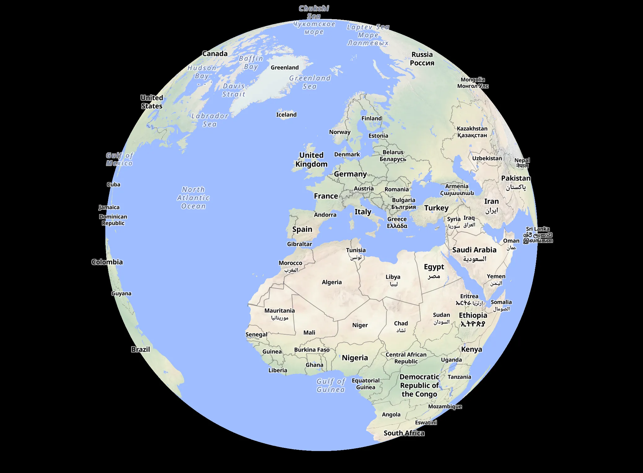
John Carmack’s globe implementation. It will probably take a while until it lands, because this is quite a big feature requiring careful review and testing. Map style based on OpenMapTiles and data from OpenStreetMap.
-
Another quite large (LLM assisted) PR implements the
global-stateexpression that was implemented earlier in MapLibre GL JS. This functionality makes it possible to define ‘variables’ for a style that you can use in various expressions. See #4516 for the PR which was submitted by Taiyu Yoshizawa from our valued sponsor MIERUNE. Reviews welcome! -
Stephan Schmid from Mercedes Benz made string expressions operate on Unicode, see #4344.
-
Vladyslav Odobesku from Intellias implemented a
CustomVectorSourcein #4377. This provides a more efficient way to load vector data when using MapLibre Android, since you can load it as binary data (in MVT format). -
@munawiki implemented
splitandjoinstyle spec expressions in #4463. -
Yaroslav Zarichnyi from Lyft implemented a customizable gradient for fill extrusions. Please give feedback on the related style spec change.
-
Bart Louwers is hacking on a C plugin API for MapLibre Native. There is also a template repository with some example plugins. The idea is that you will be able to fork this repository to easily create and release your own plugins. The current examples cover a rectangle layer, a layer that loads GLTF models and the core hillshade and heatmap layers implemented as a plugins(in the future, we might want to exclude lesser-used core layers and require people to load those as plugins to keep the core small, though we would need to ensure that plugins loaded this way do not introduce regressions). There is also a plugin for adding shadows to fill extrusions. Please share your ideas for plugins so we can use this for shaping the plugin API.
-
We moved the namespaces and include paths from
mbgltomln. Because we don’t consider the C++ API to be stable, we do not consider this a breaking change for the platforms. For in-flight work we have included some scripts in #4487 and #4511
🌐 MapLibre GL JS
Six (!) versions were released this month: 6.2.0, 6.3.0, 6.4.0, 6.4.1, 6.5.0, 6.6.0, with two new style spec properties among them.
📣 Increased release frequency is a consequence of the improved quality of the AI code generation and people actively opening PRs to solve problems that were a lot harder to solve due to steep learning curve. It’s worth mentioning that this causes delays in PR reviews due to higher volume of PRs. We hope to address this going forward, and we appreciate your patience as we work through the review queue.
fill-extrusion-rounded-corner-distancearrived in GL JS in v6.2.0, following last month’s Native-first landing, which allows you to draw rounded corners for buildings.symbol-height-offsetandsymbol-height-anchorwere added to allow raising icons and text above the map. This feature was discussed in the last two monthly meetings and after the spec matured, it is now available for your use cases, such as icons on top of building or drones in the sky.- There were also a few features related to improved icon animation by rendering on the GPU, as well as the ability to keep the perspective or flat warp in image sources.
- Going forward we intend to close the last gap between native and web by supporting the
font-facesstyle spec definition and improving complex scripts support. It’s ready for review and you can test it out via the #8237 PR. - There’s also a strong momentum for supporting some basic cases related to projection and custom CRS that started here in #8236 and is expected to continue next month.
🙏 Thanks to all the contributors this month! It’s great to see so many features and bug fixes arriving. Keep up the good work!







🦀 Martin
Martin, the MapLibre tile server, shipped two releases in August (see 1.14.0 and 1.15.0 in the changelog):
The major features were:
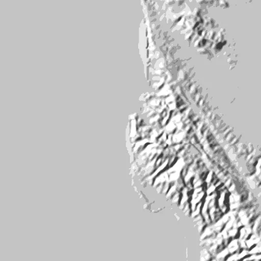
- Hillshade postprocessing. Martin can now bake shaded relief from a source serving Mapzen normal tiles, so clients get hillshade instead of a normal map they have to shade themselves. Docs, PR
- Contour postprocessing.
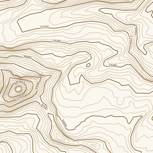
convert_to_contourtraces contour lines out of Terrarium elevation tiles and serves them as MVT, tagged with elevation and whether the line is a major one, with the interval configurable per zoom. Output is vector, so the client styles and labels the lines. Docs, PR
[!IMPORTANT] Two security advisories (our first) were fixed in 1.14.0. As always, we recomend to update. Out-of-gamut CIE colors in a static-overlay body could permanently kill render workers (GHSA-6774-6cqw-f586, affects only the opt-in
renderingfeature), and repeated sprite ids let a single unauthenticated request amplify the work required (GHSA-5x5g-6p4c-jqfh, medium).
Images of how hillshade/contour look:
Hillshade | Contour |
🤖 Maplibre Agent Skills
MapLibre Agent Skills is a collection of agent skills, markdown files an AI coding assistant loads as context, that teach assistants to write correct MapLibre code. With help from a new contributor (@johncarmack1984), the project has matured to the point where we are ready for you all to really kick the tires. The project published v0.2.0 this month. The release:
- adds
maplibre-v6-migration, covering the breaking changes in MapLibre GL JS v6 most likely to trip up coding agents. - adds
maplibre-source-wiring, split out ofmaplibre-tile-sources, for the cases where a source is configured but nothing draws. - adds a release watch that files an issue when an upstream MapLibre release removes, renames, or deprecates something a skill still mentions.
Nine skills now span cartography, tile sources, PMTiles, terrain rendering, fonts and glyphs, and Mapbox and v6 migration, plus a process skill for turning a research or coding session into a new skill.
Skills are backed by a committed baseline run of prompt injections showing the model failing without the skill. Install the set with npx skills add maplibre/maplibre-agent-skills, and if your assistant still gets MapLibre stuff wrong, file a failure report.
🪶 MapLibre Flutter
flutter-maplibre-gl has shipped v0.27.0!
After 0.26.0 tackled years of accumulated backlog, this release focuses on making the package easier to use, more consistent across platforms, and closer to the current MapLibre ecosystem.

The new documentation site: every guide comes with a live, interactive map.
Documentation | Migration Guide | Full changelog | Package
Highlights:
-
Interactive documentation site: maplibre.org/flutter-maplibre-gl now provides practical guides across the API, with live examples you can explore directly in the browser.
-
Alignment with MapLibre Style Spec: the plugin’s style APIs are now generated from the current upstream spec instead of an outdated snapshot, thereby bringing new properties and expressions.
-
Platform parity: a growing part of the API now behaves consistently across Android, iOS, and Web, including features like cluster inspection, feature state, map padding, among many others.
-
Web upgrades: The web platform now uses MapLibre GL JS 6.4.1, adding support for globe, terrain, sky, and colour relief.
-
Faster maps: Engine pre-warming cuts startup times, and large GeoJSON updates run without blocking the UI.
-
Resilient Android apps: Maps now correctly recover and preserve camera position during activity recreation.
Together, these changes move flutter-maplibre-gl closer to its goal of providing a consistent MapLibre experience across Android, iOS, and Web, while making the package easier to learn and more pleasant to use.
📣 Monthly downloads have grown from around 20,000 in August 2025 to more than 80,000 today, roughly a 4× increase in one year.
🙏 Thanks to everyone who contributed to this release and helped make MapLibre Flutter more capable, consistent, and accessible!
✨ Community Spotlight
MapLibre GL JS Ecosystem Adoption
MapLibre GL JS has recently seen notable adoption across the wider mapping ecosystem. The following are four prominent FOSS projects I’ve recently worked with to enhance their support for MapLibre:
-
deck.gl, a geospatial visualization framework, now has a dedicated
MapLibreOverlayin thedeck.glpackage. For MapLibre users, this new first-party solution replaces the reliance onMapboxOverlayand builds directly on MapLibre’s public APIs and types. As the Mapbox and MapLibre renderers diverge, this will help maintain a high level of compatibility. PR -
Placemark.io, a geospatial data editor, has replaced Mapbox GL JS with MapLibre GL JS 6, removing its remaining Mapbox dependency and making the project fully open source. The migration also moves to OpenFreeMap and provider-neutral routing. Thanks to Birk for the migration! Write-up · PR
-
Apache Superset, a data exploration and visualization platform, has added MapLibre support across its geospatial charts, with new charts defaulting to MapLibre and open basemaps that require no API key. The change will be released in Superset 6.2.0, while Mapbox remains available for backwards compatibility. PR
-
Home Assistant, a home automation platform, has moved its default basemap from CARTO raster tiles to OpenStreetMap vector tiles rendered with MapLibre GL JS through
maplibre-gl-leaflet, while continuing to use Leaflet for map interactions. PR
Expressive
Built by Zbigniew Matysek (@falseinput), Expressive is a language that compiles to MapLibre style JSON and is tailor-made for maintaining base map styles.
- It lets you split styles across files, name colors and widths once, derive one value from another, and write expressions in a readable syntax.
- Because every style JSON is already a valid Expressive file, existing styles can be rewritten piece by piece.
- Checkout the source code or interactive demo, which runs the OpenFreeMap Bright style rebuilt in Expressive with 119 layers driven by 15 parameters, recompiling live in your browser.
👥 Conferences & Events
Last month was packed with conference attendance across State of the Map (SOTM) Paris and FOSS4G 2026! You can explore the full schedule of talks and sessions in our MapLibre SOTM & FOSS4G Gist.
Key talks and recordings from SOTM Paris include:
- Interview from Yuri Astrakhan on MapLibre
- Being a Maintainer in the Age of LLMs by Bart Louwers
- MapLibre from data to rendering in one status update by Frank Elsinga
🗓️ Monthly meetings
We continue our regular community calls on the second Wednesday of each month, with an additional session on the last Wednesday to better accommodate Asia/Oceania time zones.
Upcoming Calls
- MapLibre Native: Sep 09, 2026 – 7:00–8:00 PM Berlin Time (UTC+2)
- MapLibre GL JS: Sep 09, 2026 – 8:00–9:00 PM Berlin Time (UTC+2)
🌏 MapLibre Eastern Call
Held on the last Wednesday of the month at an Asia/Oceania-friendly hour:
- Sep 30, 2026 – 9–10:00 AM UTC
All calls are open to everyone. Zoom links are shared in the MapLibre Slack.
Not yet a member? Request an invite via the OpenStreetMap US Slack and join the #maplibre channel.
We’d love to see you there!