Server-side raster tile rendering
Martin can render a style into raster images server-side: as XYZ tiles, or as a single static image at a chosen camera.
Warning
Rendering is not part of the default build.
It relies on maplibre_native, which links pre-compiled native libraries with strict runtime requirements.
We only ship it where we control the runtime environment.
You get it by either:
- using the
-fullDocker image variant, tagged:latest-full, or the matching-fullLinux-gnu release tarball, or - building from source with the
renderingfeature enabled (Linux only):cargo install martin --features rendering.
The default Docker image, the default release binaries, and cargo install martin do not include rendering.
Limitations of our current implementation:
- Rendering support is currently only available on Linux. To add support for macOS/Windows, please see https://github.com/maplibre/maplibre-native-rs.
- Martin does not cache rendered requests.
To enable rendering, you need a build that includes it (see above) and to turn it on in the configuration file:
Renders run on a dedicated thread pool.
rendering: true sizes it from the logical CPU count, clamped to 2..=8.
The long form sets the number of render threads explicitly, how many renderers each keeps, the tile size, and the highest pixel ratio tiles are served at:
styles:
    rendering:
        enabled: true
        workers: 4
        # Renderers each worker keeps loaded, one per style and pixel ratio [default: 8]
        renderers_per_worker: 8
        # Width and height of XYZ tiles in pixels: 256 or 512 [default: 512]
        tile_size: 512
        # Highest @{n}x pixel ratio served for XYZ tiles [default: 4]
        max_pixel_ratio: 4
        # Indexed PNG palette; `false` keeps full-color RGBA [default: max_colors 128]
        png_palette:
            max_colors: 128
Indexed (palette) PNG
Rendered PNG tiles and static images are indexed (palette) PNGs. For map tiles they are about a quarter of the size of full-color RGBA, with no visible difference. JPEG and WebP are not affected.
Each image gets the smallest palette that stays close to the full-color render, up to max_colors (2 to 256, default 128).
Encoding a tile this way takes a few milliseconds of CPU.
Set png_palette: false for full-color RGBA PNGs, for example for imagery or styles with smooth gradients:
Rendered XYZ tiles
We support generating a rasterized image for an XYZ tile of a given style.
After enabling rendering, you can use the /style/<style_id>/{z}/{x}/{y}.{filetype} API to get a <style_id>'s rendered png/jpeg content.
Tile size
Tiles are 512×512 px by default, the size MapLibre uses.
Set tile_size: 256 to serve 256×256 px tiles, the size most other raster clients (such as Leaflet or OpenLayers) expect by default.
Any other value fails at startup.
Pixel ratio
For high-density (retina) screens, add @{n}x after the row to draw the same tile at n times the pixels:
/style/<style_id>/{z}/{x}/{y}@2x.png is twice tile_size wide and high (1024×1024 px with the default 512), @3x three times.
n is a whole number from 1 up to max_pixel_ratio (4 unless configured): @5x is answered with 400 Bad Request, and a malformed suffix such as @0x or @1.5x with 404 Not Found.
In Leaflet, this is the {r}-placeholder (/style/<style_id>/{z}/{x}/{y}{r}.png), which means that on a retina screen, you get the crisp map your users expect.
Renderers per worker
Each render worker keeps a renderer for every style and pixel ratio it has been asked for, up to renderers_per_worker (8 unless configured).
Beyond that, the least recently used one is dropped, and loaded again the next time it is needed.
With tile_size: 256, the zoom 0 tile takes one more renderer per pixel ratio.
Reloading styles costs CPU on every request that misses, so set renderers_per_worker to at least the number of styles times the pixel ratios you serve.
Each renderer holds its own memory: lower renderers_per_worker or max_pixel_ratio to reduce memory usage.
Static images
Info
We currently do not have the same capabilities as Tileserver-GL to layout images. We are working on adding this feature and are very open to contributions if you want to help!
Warning
Static rendering shares the limitations listed above (Linux only, no caching).
Martin can render a single PNG/JPEG/WebP of a style at a chosen camera. The same URL is served by two methods:
GET  /style/{style_id}/static/{camera}/{size}.{ext}
POST /style/{style_id}/static/{camera}/{size}.{ext}
GET returns the base map alone.
POST additionally accepts a GeoJSON FeatureCollection in the body, with
styling on each feature's properties, and overlays those features on top
of the base style for that single render.
An empty or missing body is equivalent to GET.
Camera
The {camera} segment chooses what the image looks at:
| Form | Meaning |
|---|---|
lon,lat,zoom |
Center at (lon, lat) and zoom (north up, flat). |
lon,lat,zoom@bearing |
Center + bearing in degrees (clockwise from north). |
lon,lat,zoom@bearing,pitch |
Center + bearing + pitch in degrees. |
minLon,minLat,maxLon,maxLat |
Fit the given bounding box to the requested size. |
Info
The image is always rendered INSIDE of the requested size.
So if the bbox is [-10°,-1°,10°,1°] and size 500x500 is requested, the image will be centered on 0,0 with a 500x500 box that is fully inside the bbox, so the left-top most pixel is approximately at 1°,-1°.
We will not expand the image outside the bbox.
Size and format
{size}.{ext} follows the WIDTHxHEIGHT[@{scale}x].{ext} pattern, e.g.
800x600.png, 400x300@2x.jpg.
Allowed extensions are png, jpg, and webp.
Width and height are capped at 2048 px each; scale is capped at 4x.
Overlay body (POST)
The overlay body is a GeoJSON FeatureCollection. Each feature carries its
style on properties using
MapLibre Style Spec paint/layout
property names (circle-*, line-*, fill-*). Any property left unset falls
back to MapLibre's own default.
{
  "type": "FeatureCollection",
  "features": [
    {
      "type": "Feature",
      "geometry": { "type": "LineString",
        "coordinates": [[-10, 5], [10, 5]] },
      "properties": { "line-color": "#f00", "line-width": 3, "line-cap": "round" }
    },
    {
      "type": "Feature",
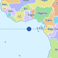
      "geometry": { "type": "Point", "coordinates": [0, 0] },
      "properties": { "circle-color": "#00f", "circle-radius": 8 }
    },
    {
      "type": "Feature",
      "geometry": { "type": "Polygon",
        "coordinates": [[[-5,-5],[5,-5],[5,5],[-5,5],[-5,-5]]] },
      "properties": { "fill-color": "#0a0", "fill-opacity": 0.5 }
    }
  ]
}
How features become layers:
- Point / MultiPoint -> one
circlelayer. - LineString / MultiLineString -> one
linelayer. - Polygon / MultiPolygon -> a
filllayer (unless onlyline-*properties are set), plus alinelayer when anyline-*property is present (so a polygon withline-colorgets an outline ofline-width). GeometryCollectionand features withgeometry: nullare silently skipped.
Anything the server can't make sense of is rejected with 400 Bad
Request: a malformed body, a top-level type that isn't
FeatureCollection, a member type that isn't Feature, an invalid CSS
color, a non-numeric width, or an unknown line-cap/line-join enum value.
Unknown property keys on feature.properties are silently ignored, so
GeoJSON files that already carry application metadata (id, name,
title, description, …) work without modification.
Supported style properties
Every property is optional; an unset property uses the MapLibre Style Spec default.
| MapLibre property | Applies to | MapLibre default |
|---|---|---|
circle-color |
Point | #000000 |
circle-opacity |
Point | 1 |
circle-radius |
Point | 5 |
circle-stroke-color |
Point | #000000 |
circle-stroke-opacity |
Point | 1 |
circle-stroke-width |
Point | 0 |
line-color |
LineString / Polygon | #000000 |
line-opacity |
LineString / Polygon | 1 |
line-width |
LineString / Polygon | 1 |
line-cap |
LineString / Polygon | butt |
line-join |
LineString / Polygon | miter |
fill-color |
Polygon | #000000 |
fill-opacity |
Polygon | 1 |
fill-outline-color |
Polygon | matches fill-color |
line-cap is one of butt, round, square; line-join is one of
miter, bevel, round. Colors accept any CSS color string.
Range checks are not enforced - *-opacity values outside 0..=1 and
negative widths are passed through to MapLibre verbatim.
Out of scope
- Data-driven expressions on individual feature properties (each feature becomes its own GeoJSON source and layer with literal paint values).
- Layer types beyond
fill/line/circle(nosymbol,heatmap,raster,fill-extrusion). - Externally-referenced GeoJSON URLs (every feature is inline).
- Symbol/icon markers (no
symbollayer) - use acircleinstead. - Z-ordering relative to base style layers - all overlay layers are drawn on top of the base style, in feature-array order.
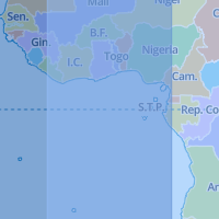
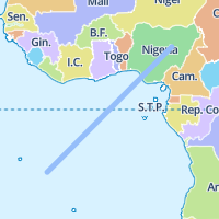
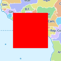
All examples below render the same camera (/static/0,0,2/200x200.png)
against the maplibre_demo style, so the visual differences come only from
the overlay body.
Line
{
  "type": "FeatureCollection",
  "features": [{
    "type": "Feature",
    "geometry": {
      "type": "LineString",
      "coordinates": [[-10.0, -10.0], [10.0, 10.0]]
    },
    "properties": {
      "line-color": "#95BEFA",
      "line-width": 5,
      "line-cap": "round",
      "line-join": "round"
    }
  }]
}
Fill
{
  "type": "FeatureCollection",
  "features": [{
    "type": "Feature",
    "geometry": {
      "type": "Polygon",
      "coordinates": [[
        [-10.0, -10.0], [10.0, -10.0],
        [10.0, 10.0], [-10.0, 10.0],
        [-10.0, -10.0]
      ]]
    },
    "properties": {
      "fill-color": "red",
      "fill-opacity": 1.0
    }
  }]
}
Fill opacity (alpha blending)
{
  "type": "FeatureCollection",
  "features": [
    {
      "type": "Feature",
      "geometry": { "type": "Polygon",
        "coordinates": [[[-40, -20], [10, -20], [10, 20], [-40, 20], [-40, -20]]] },
      "properties": {
        "fill-color": "#285DAA",
        "fill-opacity": 0.5
      }
    },
    {
      "type": "Feature",
      "geometry": { "type": "Polygon",
        "coordinates": [[[-10, -20], [40, -20], [40, 20], [-10, 20], [-10, -20]]] },
      "properties": {
        "fill-color": "#95BEFA",
        "fill-opacity": 0.5
      }
    }
  ]
}